Civil Site Design | Road Reconstruction (Online)

Tailored for civil engineers involved in road reconstruction projects, this program enables designers to proficiently create, edit, analyse, and publish road reconstruction design models using Civil Site Design. Engage in hands-on learning with practical exercises. Experienced instructors provide insights to competently design roads and strings, generate volumes, and output profile and section views.

Description

Designed for civil engineers involved in road reconstruction , this comprehensive program empowers civil designers to create, edit, analyse and publish road reconstruction projects using Civil Site Design. 

Throughout the course, participants will engage in practical exercises and real-world examples, fostering a hands-on learning environment. Our experienced instructors will guide you through each module, providing valuable insights and tips to empower you to competently undertake various road reconstruction projects, generate design models, and output setout, long sections, cross sections, plan linework and 3D model viewing. By the course's conclusion, participants will have acquired the essential skills to confidently navigate and leverage Civil Site Design for their road reconstruction projects.


Pre Requisites

The training data set will have Civil 3D Surfaces & Alignments created in the drawing, therefore  trainees must have knowledge and understanding of operating Civil 3D Surfaces & Alignments.

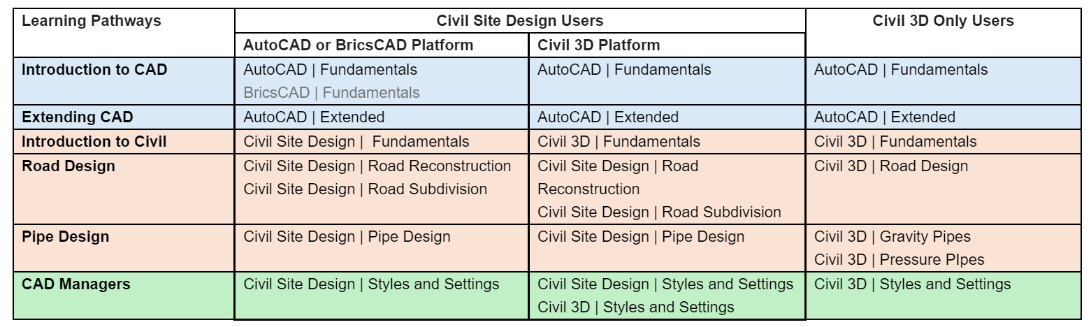
This course parallels much of the learning in the Civil Site Design | Road Subdivision Fundamentals but with more focus on the road reconstruction functionality and exploring road reconstruction projects.

Course Outline

Civil Site Design Strings Introduction. Strings form the foundation of Civil Site Design.  Understand what a String is and how they are used in road reconstruction projects.

Civil Site Design Templates. Templates are a fundamental building block of Civil Site Design to represent design cross sections.  Explore the functionality to create Templates suitable for various reconstruction projects including management of pavement layers.

Civil Site Design Grading. Extending upon the Fundamentals course, deep dive into the process for using site grading for non linear design elements, such as islands, pads, retaining walls and more.  

Civil Site Design Road Strings and Models. Understand the power of Road Strings in road reconstruction, including management of the vertical design and cross sections to describe various reconstruction projects.  We’ll look into applying Templates and editing cross section codes, and see how design surface models can be constructed of your designs.  

Civil Site Design Network Strings. Understand how to incorporate kerb returns into your models to represent intersections, manage vertical design and cross sections through intersection zones.

Civil Site Design - Design Aids. Maximise your design efficiency by implementing design constraints and surface extensions to guide your vertical designs within crossfall constraints.

Civil Site Design Modelling. We will introduce you to the power of design models to build surfaces (including subgrade surfaces), calculate volumes and create cross section outputs representing your road reconstruction designs.

Civil Site Design Outputs. After all the work in design, see how to quickly and accurately produce outputs: point setout, long sections, cross sections and reports.

Similar courses

Free with registration. This self paced video based course is designed to teach you how to start using and fully understand Civil Site Design on your chosen CAD platform.

More Information

Instructor Led. Get started in AutoCAD with our fundamentals training. Hands-on learning with seasoned instructors ensures essential skills for precise drafting in engineering projects. Ideal for fresh graduates and seasoned professionals, our course builds a solid CAD foundation, streamlining design processes and elevating engineering capabilities.

More Information

Instructor Led. Advance your CAD skills with our tailored AutoCAD Extended course. Led by experienced AutoCAD specialists, it explores advanced functionalities such as 3D modeling and parametric design. Equip yourself with tools for complex projects, from advanced documentation to collaboration. Gain a strategic advantage, leading projects with precision or staying at the forefront of industry advancements.

More Information

Instructor Led. Tailored for civil engineers, surveyors, and CAD professionals, this program offers a robust foundation in Autodesk Civil 3D, a key software in civil engineering design. Engage in hands-on learning with practical exercises and real-world examples. Experienced instructors provide valuable insights, enhancing proficiency. Acquire essential skills to confidently navigate and leverage Civil 3D for surveys and designs, laying the groundwork for success in civil engineering projects.

More Information

Free with registration. This is a short overview course to introduce you to the pipes module within Civil Site Design.

More Information

Free with registration. This video based course is designed to teach you how to exchange data between Civil Site Design and Civil 3D - create surfaces, alignments, profiles, profile views, assemblies and corridors all from your Civil Site Design models.

More Information

eLearning for the AEC industry. Access to the largest online catalogue of eLearning material for all major Autodesk products. Also includes Bentley, Adobe, BIM Management and more.

More Information

Instructor Led. The AutoCAD Fundamentals course teaches you everything you need to know to become quickly productive with the software.

More Information

Instructor Led. Tailored for civil engineers in pipe design, this program enables designers to proficiently create, edit, and publish pipe networks using Civil Site Design. Experienced instructors empower you to competently design stormwater, sewer, property connection and utility networks including outputting reports, plan labels and long sections. Acquire essential skills for leveraging Civil Site Design in pipe design projects.

More Information

Instructor Led and supported with GeT resources. Autodesk Revit Architecture The Complete Guide is designed to give you a solid understanding of Revit Architecture, its features and capabilities, from the basics through to the most advanced and complex topics. data with engineers and contractors. It is software for architectural design, MEP, and structural engineering, and a solution for collaborative BIM; its powerful tools let you use the intelligent model-based process to plan, design, and construct

More Information

Instructor Led and supported with GeT equips participants with essential Autodesk ReCap skills. Starting with an introduction, delve into point cloud fundamentals and UI. Learn view/navigation techniques, customize appearances, and master organising/editing. Progress to measurement, labelling, and advanced topics like Registration and UAV features. Culminate with insights into the iPad app for on-the-go reality capture. Gain a comprehensive understanding for efficient handling of point cloud data.

More Information

Instructor Led. Tailored for civil engineers, surveyors, and CAD professionals, this program offers a robust foundation in Autodesk Civil 3D, a key software in civil engineering design. Engage in hands-on learning with practical exercises and real-world examples. Experienced instructors provide valuable insights, enhancing proficiency. Acquire essential skills to confidently navigate and leverage Civil 3D for surveys and designs, laying the groundwork for success in civil engineering projects.

More Information

Instructor Led. Tailored for civil engineers in road design, this program enables designers to proficiently create, edit, analyse, and publish corridors using Autodesk Civil 3D. Engage in hands-on learning with practical exercises. Experienced instructors provide insights to competently design corridors, generate volumes, and output profile and section views. Acquire essential skills for confident navigation and leveraging Civil 3D in road design projects.

More Information

Instructor Led. Tailored for civil engineers in pipe design, this program enables designers to proficiently create, edit, and publish pipe networks using Autodesk Civil 3D. Engage in hands-on learning with practical exercises. Experienced instructors provide insights to competently design pipe networks generate reports, and output profile and section views. Acquire essential skills for confident navigation and leveraging Civil 3D in pipe design projects for geometric design.

More Information

Instructor Led. Tailored for civil engineers involved in road subdivisions designs, this program enables designers to proficiently create, edit, analyse, and publish road network design models using Civil Site Design. Engage in hands-on learning with practical exercises. Experienced instructors provide insights to competently design roads and strings, generate volumes, and output profile and section views. Acquire essential skills for confident navigation and leveraging Civil Site Design in road projects.

More Information

Tailored for civil engineers in pipe design, this program enables designers to proficiently create, edit, and publish pipe networks using Civil Site Design. Experienced instructors empower you to competently design stormwater, sewer, property connection and utility networks including outputting reports, plan labels and long sections. Acquire essential skills for leveraging Civil Site Design in pipe design projects.

More Information

Instructor Led. This course introduces surveyors to the functionality in Stringer Topo to work with COGO Points, manage point groups, create survey linework and build survey surfaces, complete with output of labels and tables, as well as touching on the cadastral toolset in Stringer Topo. Acquire essential skills for leveraging Stringer Topo for your various survey projects.

More Information

Instructor Led. This course introduces surveyors to the functionality in Stringer Topo to work with COGO Points and surfaces in Civil 3D. Explore Civil 3D and Stringer Topo to manage points and point groups, create survey linework and build Civil 3D surfaces, generate legend tables, and look at the cadastral tools in Civil 3D and Stringer Topo. Acquire essential skills for leveraging Stringer Topo for your various survey projects.

More Information

Instructor Led. The AutoCAD Extended course extends upon the AutoCAD Fundamentals course to expand your knowledge of the inner workings of AutoCAD.

More Information

Instructor Led. Tailored for civil engineers in road design, this program enables designers to proficiently create, edit, analyse, and publish corridors using Autodesk Civil 3D. Engage in hands-on learning with practical exercises. Experienced instructors provide insights to competently design corridors, generate volumes, and output profile and section views. Acquire essential skills for confident navigation and leveraging Civil 3D in road design projects.

More Information

Instructor Led. Built for all CAD managers and staff involved in the standardisation of presentation outputs, this course deep dives into the styles and settings in Civil Site Design that drive the command behaviours and control the presentation of outputs. Understand how to manage all Civil Site Design outputs: linework display, long sections, cross sections, setout and more. This course assumes you have a working knowledge of Civil Site Design.

More Information

In this Level 1 course you will be introduced to the fundamentals of Autodesk Revit Architecture. Lead by a registered architect, you will be guided through the development of a real architectural project and learn the key principles necessary for you to begin designing your own buildings.

More Information